9 Days Climbing Kilimanjaro via Lemosho Crater Route
Trekking Overview
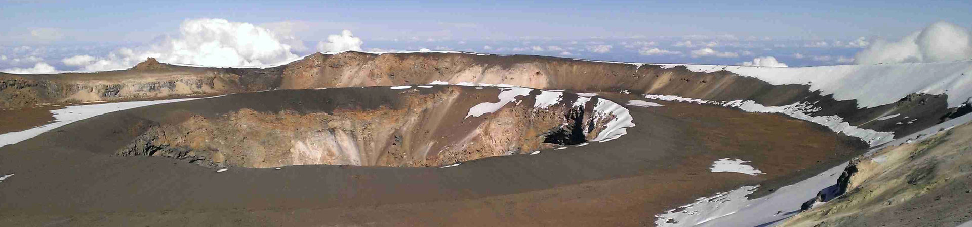
Crater Camp is a unique place. At 18,865 feet above sea level, it is the highest campsite on Mount Kilimanjaro. It is located just 475 feet below the summit. We offer the opportunity to stay at Crater Camp on the Lemosho and Northern Circuit routes. This option will add one day to the standard itineraries making them the 9 Lemosho Crater Route and 10-day Northern Crater Route.
We leave for the summit during daylight hours and stay at Crater Camp after the summit for better acclimatization. On all other Kilimanjaro routes, only the guides and clients summit while the rest of the mountain crew remains at high camp (i.e. Barafu).
Using Crater Camp requires significantly more effort on our part as the entire mountain crew, along with all of the expedition equipment, has to ascend 4,000 feet higher than they normally would. Therefore, there is considerable added cost to do a Crater Camp route.
From Crater Camp, one can take an optional one-hour hike to Reusch Crater, or simply explore the areas around Furtwangler Glacier. Reusch Crater is a magnificent sight.
It is almost perfectly circular and the ash pit measures 400 feet (120 m) deep and 1,300 feet (400 m) wide. This is rarely seen by tourists. The video below puts the size of the ash pit and crater into perspective.
Day 1: Londorossi Gate to Mti Mkubwa
Elevation: 7,742 ft. to 9,498 ft.
Distance: 6 km/4 miles
Hiking Time: 3-4 hours
Habitat: Rain Forest
We depart Moshi for Londorossi Gate, which takes about 4 hours, where you will complete entry formalities. Then drive to the Lemosho trailhead. Upon arrival at trailhead, we begin hiking through undisturbed forest which winds to the first camp site.
DAY 2: Mti Mkubwa to Shira 1 Camp
Elevation: 9,498 ft. to 11,500 ft.
Distance: 8 km/5 miles
Hiking Time 5-6 hours
Habitat: Health
We continue on the trail leading out of the rain forest and into a savannah of tall grasses, heather and volcanic rock draped with lichen beards. As we ascend through the lush rolling hills and cross several streams, we reach the Shira Ridge before dropping gently down to Shira 1 Camp. Here we catch our first glimpse of Kibo across the plateau.
DAY 3: Shira 1 Camp to Moir Hut
Elevation: 11,500 ft. to 13,800 ft.
Distance: 11 km/7 miles
Hiking Time: 5-7 hours
Habitat: Heath
We explore the Shira Plateau for a full day. It is a gentle walk east on moorland meadows towards Shira 2 Camp. Then we divert from the main trail to Moir Hut, a little used site on the base of Lent Hills. A variety of walks are available on Lent Hills making this an excellent acclimatization opportunity. Shira Plateau is one of the highest plateaus on earth.
DAY 4: Moir Hut to Lava Tower
Elevation: 13,800 ft. to 15,190 ft.
Distance: 7 km/4 miles
Hiking Time: 4-5 hours
Habitat: Alpine Desert
Lava Tower to Barranco Camp
Elevation: 15,190 ft. to 13,044 ft.
Distance: 3 km/2 miles
Hiking Time: 2-3 hours
Habitat: Alpine Desert
We begin the day climbing up a ridge and then head southeast towards the Lava Tower – a 300 ft tall volcanic rock formation. We descend down to Barranco Camp through the strange but beautiful Senecio Forest to an altitude of 13,000 ft. Although you begin and end the day at the same elevation, the time spent at higher altitude is very beneficial for acclimatization.
DAY 5: Barranco Camp to Karanga Camp
Elevation: 13,044 ft. to 13,106 ft.
Distance: 5 km/3 miles
Hiking Time: 4-5 hours
Habitat: Alpine Desert
We begin the day by descending into a ravine to the base of the Great Barranco Wall. Then we climb the non-technical but steep, nearly 900 ft cliff. From the top of the Barranco Wall we cross a series of hills and valleys until we descend sharply into Karanga Valley. One more steep climb up leads us to Karanga Camp. This is a shorter day meant for acclimatization.
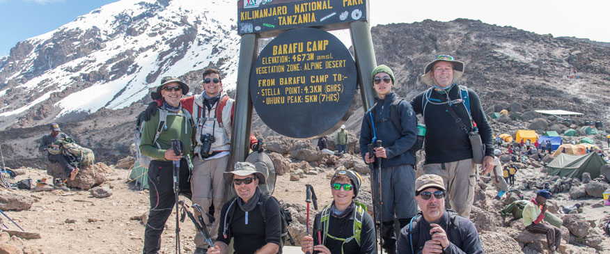
DAY 6: Karanga Camp to Barafu Camp
Elevation: 13,106 ft. to 15,331 ft.
Distance: 4 km/2 miles
Hiking Time: 4-5 hours
Habitat: Alpine Desert
We leave Karanga and hit the junction which connects with the Mweka Trail. We continue up to the rocky section to Barafu Hut. At this point, you have completed the Southern Circuit, which offers views of the summit from many different angles. Here we make camp, rest and enjoy an early dinner to prepare for the summit day. The two peaks of Mawenzi and Kibo are viewable from this position.
DAY 7: Barafu Camp to Uhuru Peak
Elevation: 15,331 ft. to 19,341 ft.
Distance: 5 km/3 miles
Hiking Time: 7-8 hours
Habitat: Arctic
Uhuru Peak to Crater Camp
Elevation: 19,341 ft. to 18,865 ft.
Distance: 1 km/.6 miles
Hiking Time: 0.5-1 hours
Habitat: Artic
During normal morning hours, we begin our push to the summit. This is the most mentally and physically challenging portion of the trek. We ascend for several hours at a slow but steady pace while taking frequent, but short, breaks.
The trail turns into heavy scree as we make the steep climb to the crater rim. At Stella Point (18,900 ft.), we see the summit sign in the distance. We continue the around the crater rim until finally we arrive at Uhuru Peak- the highest point on Mount Kilimanjaro and the continent of Africa.
We then descend a short distance to Crater Camp, where the rest of the staff will join us to set up camp. There is an option to hike to Reutsch Crater and the ash pit, or simply explore the areas around Furtwangler Glacier.
Sleeping at this high altitude can be dangerous. Serious AMS can develop if adequate altitude acclimatization has not been achieved so the guides will monitor you very closely.
DAY 8: Crater Camp to Mweka Camp
Elevation: 18,865 ft. to 10,065 ft.
Distance: 12 km/7 miles
Hiking Time: 4-6 hours
Habitat: Artic
From Crater Camp, we now make our descent continuing straight down to the Mweka Hut camp site, stopping at Barafu for lunch. The trail is very rocky and can be quite hard on the knees; trekking poles are helpful. Mweka Camp is situated in the upper forest and mist or rain can be expected in the late afternoon. Later in the evening, we enjoy our last dinner on the mountain and a well-earned sleep.
DAY 9: Mweka Camp to Mweka Gate
Elevation: 10,065 ft. to 5,380 ft.
Distance: 10 km/6 miles
Hiking Time: 3-4 hours
Habitat: Rain Forest
On our last day, we continue the descent to Mweka Gate and collect the summit certificates. At lower elevations, it can be wet and muddy. From the gate, we continue another hour to Mweka Village. A vehicle will meet us at Mweka Village to drive us back to the hotel in Moshi.
Search our web
Related Links
- DESTINATIONS (4)
- KILIMANJARO TREKKING (9)
- Crater Lemosho Route (1)
- Lemosho Route (1)
- Machame Route (1)
- Marangu Route (1)
- Northern Circuit Route (2)
- Rongai Route (1)
- Shira Route (1)
- Umbwe Route (1)
- SAFARIS (24)
- Kenya Safaris (9)
- Rwanda-Safaris (7)
- Tanzania Safaris (1)
- Uganda Safaris (7)
- SAFARIS IN TANZANIA (18)
- Camping Safaris (7)
- Cultural Tours (3)
- Day Trip (1)
- Family Vacation (1)
- Lodge Safaris (6)
- Migration Safaris (2)
- TANZANIA SAFARIS PARK (8)
- Uncategorized (2)
- ZANZIBAR & BEACH HOLIDAYS (7)
- Beach Vacation (4)
Send us A Quote !!

Let's Get In touch on Facebook
Price Includes
- Overnight stays in mountain Huts
- Professional, experienced, mountain guides:
- Mountain Equipment, Sleeping tents, Kitchen tents, Porters, Guides and Chef
- Tents, Table and Chairs, Food utensils and so on.
- All Park fees
- Rescue fees
- All meals while on the Mountain
- Guides, Porters, cook salaries and park fees
- Quality Mess tents with table and chairs
- Large portions of fresh, healthy nutritious food
- Clean, purified drinking water
- Crisis management and safety procedures
- Fair and ethical treatment of porters
Price Excludes
- Airport transfers
- Accommodation in Arusha
- Tanzania Visa
- Gratuity
- Personal Expenses (e.g. laundry, telephone, beverages, etc.)
- Meals not listed above